
Coastal Regulation Zone (CRZ) & Coastal Zone Management (CZM) Framework 2026: India's Compliance Guide
-
Home
-
Regulatory Updates
-
Coastal Regulation Zone (CRZ) & Coastal Zone Management (CZM) Framework 2026: India's Compliance Guide



The Coastal Zone Management (CZM) Regulatory Landscape
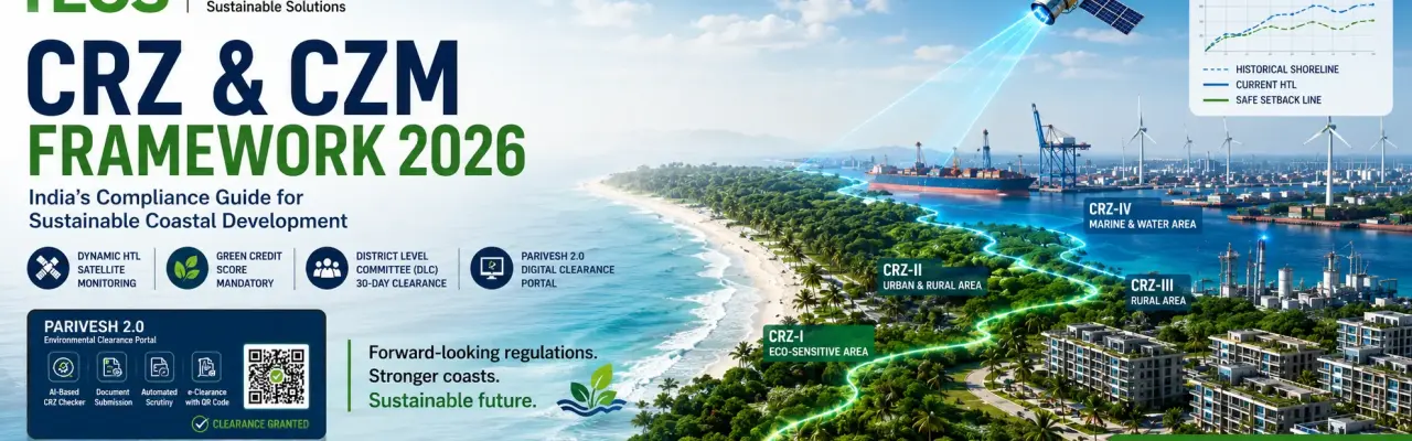
Quick Answer: What's new in CRZ/CZM compliance for 2026?India's Coastal Regulation Zone (CRZ) framework has moved from static map-based zoning to a real-time, digitally governed Integrated Coastal Zone Management (ICZM) system. For 2026, three changes matter most: Dynamic HTL demarcation via satellite telemetry, a mandatory Green Credit Score for clearance, and District Level Committee (DLC) approval for smaller CRZ-II/III projects in 30 working days instead of 60. All clearances now run through the PARIVESH 2.0 portal. |
As India approaches 2026, the Coastal Regulation Zone (CRZ) framework has evolved from a restrictive zoning mechanism into a dynamic Integrated Coastal Zone Management (ICZM) system. Coastal Zone Management (CZM) is the ongoing process of managing coastal and marine areas to achieve sustainability — balancing economic development, tourism, and human settlement with the protection of fragile ecosystems. The regulatory focus has shifted decisively toward climate resilience, Blue Economy acceleration, and real-time digital governance.
India has a very long coastline — about 7,516.6 km bordering the mainland and the islands, with the Bay of Bengal to the east, the Indian Ocean to the south, and the Arabian Sea to the west. This figure has been re-assessed to 11,098.81 km (MES, 2025).
The coastal zone is the area of interaction between land and sea. The High Tide Line (HTL), Low Tide Line (LTL), and other environmentally sensitive features — mangroves, corals, sand dunes, biologically active mudflats, protected areas, salt marshes, turtle nesting grounds, [term to verify: "horse habitats" — confirm intended terminology, e.g. horseshoe crab habitats], sea grass beds, bird nesting grounds, and heritage sites — must be demarcated in CRZ maps by agencies authorised by the MoEFCC (Procedure for Clearance of Preamble Activities, 2022).
As per the CRZ Notification, 2011/2019, any development activity within a CRZ area must obtain prior CRZ Clearance from the concerned authority — MoEFCC, GoI / SEIAA / local planning authorities (DTCP/CMDA) — after recommendation by the concerned State Coastal Zone Management Authority (SCZMA). This was further clarified by the MoEFCC, GoI, vide Office Memorandum No. 1A3-12/1/2022-IA.III, dated 26.04.2022.
1. 2026 Framework: Key Regulatory Shifts & Updates
The Government of India has introduced several policies under the CRZ Notification to safeguard the country's coastal areas. These measures protect fragile coastal ecosystems from unchecked urbanisation and industrialisation, and safeguard the livelihoods of traditional fishing communities who depend on coastal resources for survival.
CRZ regulations also help maintain coastal regions as natural buffers against climate change impacts such as sea-level rise, cyclones, storms, and coastal erosion. By controlling development activities in sensitive zones, the framework promotes sustainable development while preventing irreversible environmental damage — balancing economic growth with the long-term health and resilience of India's coastal and marine ecosystems.
India's CRZ framework, rooted in the Environment (Protection) Act, 1986, has evolved to balance environmental protection with development needs — shifting from rigid restrictions in 1991 to more decentralised, development-oriented guidelines in 2011 and 2019, while increasingly addressing climate change and traditional community rights. Powers of the Central/State Coastal Zone Management Authority (SCZMA) have been further delegated. The regulatory environment in 2026 represents the full operationalisation of amendments initiated between 2019 and 2024. The following updates are currently in force:
A. Dynamic HTL & LTL Demarcation (Real-Time Monitoring)
Moving beyond static maps, the 2026 framework mandates Dynamic HTL (High Tide Line) demarcation.
Regulation: HTL is now monitored via satellite telemetry linked to the Indian Coastal Spatial Decision Support System (IC-SDSS).
Compliance impact: Project boundaries are verified against real-time shoreline data, accounting for seasonal erosion/accretion, so that "fixed" structures do not end up violating shifting tidal boundaries.
B. Integration of the Green Credit Programme (GCP)
In alignment with India's Green Credit Programme, CRZ clearances from 2026 onward require a mandatory Green Credit Score.
New mandate: Developers must quantify their environmental footprint. Projects achieving a "Net Positive" impact through mangrove restoration or artificial reef creation earn Green Credits, which expedite clearance timelines via the PARIVESH 2.0 portal.
Trade-off: Projects in CRZ-III (Rural) zones can avail of increased Floor Space Index (FSI) upon submission of a verified Green Credit certificate.
C. Decentralised Clearance: District Level Committees (DLCs)
To fast-track local infrastructure, the powers of the SCZMA have been further delegated.
Update: Projects with a built-up area of less than 20,000 sq.m in CRZ-II, and specific fishing infrastructure in CRZ-III, are now cleared exclusively by District Level Committees (DLCs).
Timeline: The mandatory clearance timeline for DLC-level projects has been reduced from 60 days to 30 working days.
2. Sector-Specific Regulatory Updates (2026)
This section outlines the operational mandates, clearance pathways, and strategic compliance requirements for coastal infrastructure, housing, and industrial projects under the current framework.
Housing & Real Estate (CRZ-II & III)
Reduced NDZ permanence: The reduced "No Development Zone" (NDZ) of 50 metres for densely populated rural areas (CRZ-IIIA) is now standard.
TDR integration: Transfer of Development Rights (TDR) is fully operational in major coastal cities (Mumbai, Chennai, Kochi, etc.). Developers can now utilise TDR generated from slum rehabilitation projects in CRZ-II areas without additional state government ratification.
Ports & Blue Economy (CRZ-IV)
Strategic port infrastructure: The definition of "Strategic Projects" has been expanded to include Green Hydrogen Hubs and Offshore Wind Energy Terminals.
Regulatory relief: These projects are exempt from standard CRZ clearance, requiring only an Environmental Management Plan (EMP) vetted by a designated Nodal Agency — speeding up the transition to blue energy.
Coastal Tourism
Eco-tourism protocols: 2026 regulations strictly enforce "temporary and reversible" structures in CRZ-I and CRZ-III eco-tourism zones.
Ban on concretisation: Hard surfacing (concrete roads/parking) within the NDZ is prohibited; only permeable, bio-engineering solutions are permitted.
3. Mandatory Compliance Deliverables (2026 Checklist)
To secure clearance under the 2026 regime, the following technical deliverables are mandatory for submission on the PARIVESH 2.0 portal:
CRZ 2026 mandatory compliance deliverables and regulatory requirements
S.No | Deliverable | Regulatory Requirement |
| 1 | Dynamic CRZ Classification Map | Geo-referenced CRZ map validated against the latest IC-SDSS database, ensuring compliance with current Coastal Regulation Zone notifications and spatial datasets. |
| 2 | HTL/LTL Demarcation Survey | High Tide Line (HTL) and Low Tide Line (LTL) demarcation certified by an empanelled agency, including a 10-year historical shoreline change analysis as required for regulatory approval. |
| 3 | Climate Hazard Vulnerability Assessment | Mandatory for projects exceeding 5,000 sq. m. Assessment must evaluate sea-level rise, cyclone storm surge, coastal flooding, and long-term climate risks over a 50-year planning horizon . |
| 4 | Shoreline Change Analysis Report | Scientific assessment of historical shoreline movement, quantifying erosion and accretion rates to establish statutory setback lines and support CRZ project planning. |
| 5 | Biodiversity Management Plan (BMP) | Required for developments affecting CRZ-I ecologically sensitive areas , including mangroves, coral reefs, mudflats, and nesting grounds. Includes a 3-year biodiversity monitoring programme using IoT-enabled environmental monitoring systems. |
6 | Green Credit Certificate | Documentary evidence demonstrating compliance with afforestation, ecosystem restoration, or conservation obligations under the Green Credit Programme, where applicable. |
4. The Compliance Process: PARIVESH 2.0 Integration
The 2026 process is fully automated. Here is the official workflow:
Pre-feasibility check: Proponents must use the AI-based "CRZ Checker" module on PARIVESH 2.0 to validate site coordinates against the live CRZ atlas.
Document upload: Submission of GIS-ready shape files (KML/SHP) for HTL and project layout. PDFs are no longer accepted for primary analysis.
Automated scrutiny: The system automatically cross-checks the project layout with the Hazard Line and NDZ limits. Human intervention is minimised to reduce bias.
Virtual site inspection: For projects in sensitive zones, the State Authority conducts a drone-based virtual inspection rather than a physical site visit.
Grant of EC/CRZ clearance: Issued as a digital certificate with a unique QR code linked to the Digital Green Credit Ledger.
5. Strict Monitoring & Enforcement Mechanisms
The 2026 framework uses technology for rigorous post-clearance monitoring:
Satellite telemetry: High-resolution satellite imagery is used to detect unauthorised construction within NDZs quarterly.
IoT sensors: Major industrial units in CRZ-IV are mandated to install real-time effluent and emission sensors linked to the CPCB server.
Erosion Response Protocol: If a project site experiences accelerated erosion exceeding 2% annually, construction is automatically suspended until a new Shoreline Protection Plan is in place.
6. Official Guidelines & Resources (2026)
MoEFCC Circular 2026/03: Guidelines for Green Credit integration in coastal projects.
NCSCM Technical Manual: Standard Operating Procedure for Dynamic HTL Demarcation using LiDAR.
PARIVESH 2.0 User Manual: Guide to the AI-based Scrutiny Module.
Conclusion: How HECS Supports Seamless CRZ Compliance in 2026
The CRZ regulatory framework for 2026 marks a clear shift toward sustainability driven by technology. With dynamic GIS-based mapping, digitised approvals through the PARIVESH portal, decentralised mechanisms, and incentive-based models such as Green Credits, the government is working to accelerate responsible coastal development while protecting India's ecological frontier. Successful clearance now depends more than ever on scientific and technical precision combined with regulatory understanding — accurate HTL/LTL demarcation, compliant CRZ mapping, hazard line validation, and properly structured documentation are critical to avoiding delays or rejections.
By aligning development activities in sensitive zones with sustainable practices and preventing irreversible environmental damage, HECS (Hubert Enviro Care Systems) helps project proponents stay ahead of regulatory expectations.




| Disclaimer: This content reflects the projected operational status of the CRZ 2011/2019 Notifications as envisaged for 2026, incorporating current government policy direction on digital governance (PARIVESH) and the Green Credit Programme. It is for informational purposes only and does not constitute official or legal advice. For binding requirements, verify against current MoEFCC, SCZMA, and PARIVESH 2.0 notifications. No liability is accepted for errors, omissions, or regulatory changes after publication. |
Share this service: